
Thailand is widely acknowledged as having the most extensive road transportation network in all of Southeast Asia with more than 390,026 kilometers, of which 384,176, or 98.5%, is concrete or asphalt paved, and 66,266 km forming a national highway network connecting each region of the country.
The Department of Highways continues to improve and expand the country’s roadways. They has developed the concept of a 20-year Intercity Motorway Development Master Plan for the period 2017 – 2036, comprising 21 routes with a total length of 6,612 km.
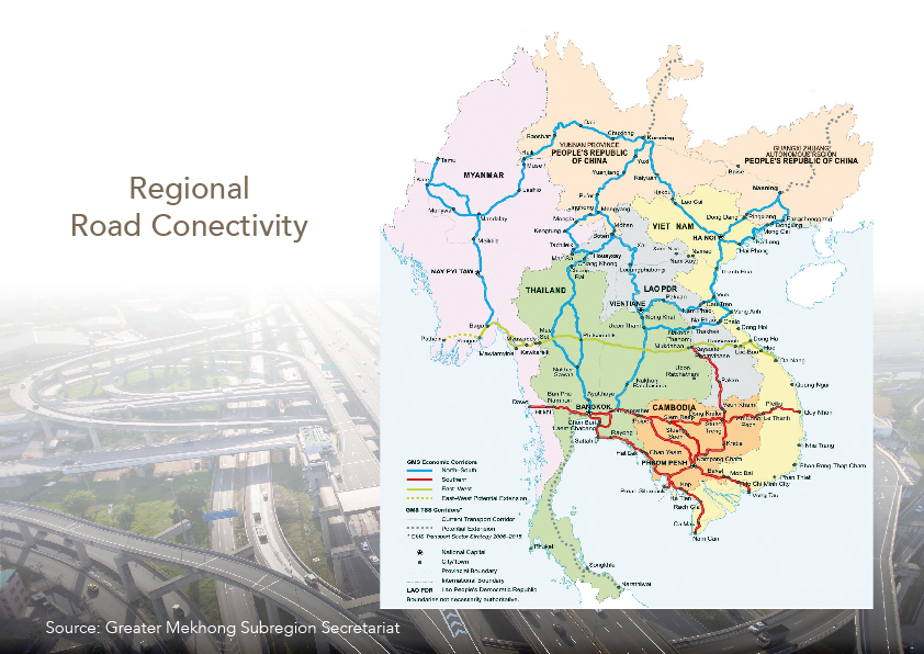 |
New highways throughout the country will eventually become part of the East-West Economic Corridor (EWEC), which will link the South China Sea with the Bay of Bengal, and the North-South Corridor which will link Singapore with Kunming in China.
The Greater Mekong area road network already includes a southern economic corridor inclusive of Thailand, Cambodia and Vietnam; the east-west economic corridor linking Myanmar, Thailand, Laos and Vietnam; the north-south economic corridor which runs from southern China through Laos and Myanmar, and into Thailand; and the southern coastal economic corridor also connecting Thailand, Cambodia and Vietnam. All major cities in Thailand are accessible by land, with all-weather highways and intercity roads linking them to the road network covering the whole country, as well as the Asian Highway and the road networks of neighboring countries at border crossings.
Sources: The Department of Highways as of 27 December 2018
Road Network Links between Dawei Port and Laem Chabang
The linkage between Thailand’s Eastern Seaboard and Myanmar’s Dawei will provide immense business opportunities as the emerging economic driver in the region. With high potential to open the western gateway for existing production bases in East Asia, the new trade and transportation route will create a “logistics shortcut” for the region. Also, the supersized co-production base will be an important growth node linking the GMS region to global markets.
The biggest port, which was endorsed by the governments of Thailand and Myanmar, has attracted the attention of many investors. The new project will be built as a deep-water port with associated industrial, residential and resort complexes and all attendant infrastructure.
The US$50 billion project is being led by the Italian-Thai Development Company, which is seeking investors to get the massive undertaking on the move. A tentative date of 2018 has been given for the opening of the first phase of the port. In the near future, the new motorway (Kanchanaburi-Bann Pu Nam Ron & Bang Yai-Kanchanburi) and rail links between Laem Chabang port in Thailand and the new facility at Dawei in Myanmar will forge cooperation rather than rivalry between the two.
Bus
The mass transit system includes both buses and trains. Bangkok has approximately 250 bus lines providing service for a total of 5,000 kilometers in every area of Bangkok and its suburbs. In the provinces, hundreds of entrepreneurs operate Bangkok-suburb routes and other routes nationwide. There are three main bus terminals: the Northern and Northeastern Terminal, the Southern Terminal, and the Eastern Terminal.
Travel by bus is inexpensive and convenient, especially if using the VIP buses. There also are regular air conditioned buses and non-air conditioned buses. The latter make frequent stops, thus extending travel times.
BRT (Bus Rapid Transit)
BRT is a new transit system in Bangkok connecting Sathon to Ratchaphruek, and which opened to the public on 29 May 2010 with a total distance of 15.9 km with 12 stations. Presently, he ticket price is 10 and 15 baht and the BRT system encourages commuters to use the BTS Skytrain as a convenient means to move around the city.
Highway Basics
 |
The Thai highway network follows left-hand lane traffic rules.
Sources : Ministry of Transportation, Department of Highways, Public Relations Department and Tourism Authority of Thailand Last updated : 18 June 2019